CompassAVL empowers municipalities, public works departments, and utility providers to share real-time vehicle location for real-life impact with the public—improving service transparency, boosting citizen trust, and reducing inbound status requests. Designed for snowplows, street sweepers, trash collection, and more, it bridges the gap between internal operations and public awareness while keeping field crews safe and accountable.
Smart Public Sharing with Built-In Operational Privacy
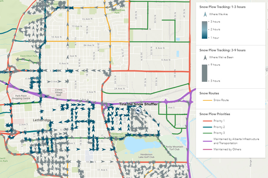
Live for Supervisors, Delayed for the Public: provide operations teams with real-time AVL software visibility while showing the public a time-delayed view—enhancing safety, reducing interference, and maintaining transparency.
Public Delay Control: configure how much location delay is shown to the public, preventing real-time visibility of active crews without sacrificing accountability.
Idle Vehicle Filtering: automatically hide parked or idling fleet vehicles—such as those on break or in maintenance—from the public-facing viewer to keep maps clean and useful.
Geofenced Privacy Zones: exclude sensitive areas like staging yards, depots, and restricted zones using configurable geofences to ensure operational security.
Smart Public Sharing with Built-In Operational Privacy
Live for Supervisors, Delayed for the Public: Provide operations teams with real-time location for real-life impact AVL software visibility while showing the public a time-delayed view—enhancing safety, reducing interference, and maintaining transparency.
Public Delay Control: configure how much location delay is shown to the public, preventing real-time location for real-life impact visibility of active crews without sacrificing accountability.
Idle Vehicle Filtering: automatically hide parked or idling fleet vehicles—such as those on break or in maintenance—from the public-facing viewer to keep maps clean and useful.
Geofenced Privacy Zones: exclude sensitive areas like staging yards, depots, and restricted zones using configurable geofences to ensure operational security.
"The City of Lake Stevens uses the CompassComAVL™ Viewer for our snow plow public viewing dashboard. With the Public Viewer using Esri, the integration with our own GIS data was flawless, and it is highly reliable being built on an industry-leading codebase."
Zachary Kathe
GIS Application Analyst – City of Lake Stevens
From snowplows and street sweepers to waste collection and spraying trucks, CompassAVL gives your team and your community a real-time location for real-life impact, a public-facing view of active service vehicles while automatically hiding inactive or sensitive locations to maintain security and professionalism.